

Introduction
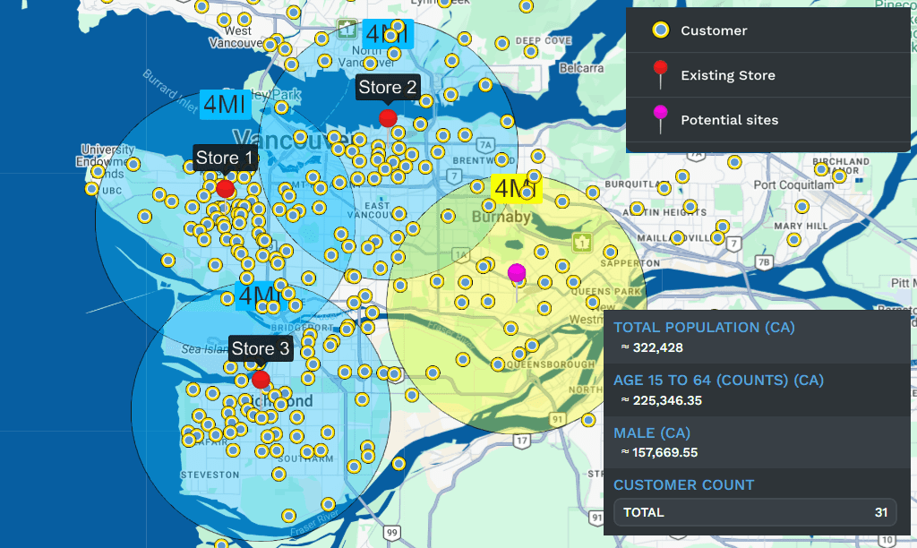
Understanding distance on a digital map is not always as simple as looking at a number. Saying that a location is five miles away may provide useful information, but it does not immediately show the full area surrounding that point. A map radius visualizer makes this information easier to understand by turning a selected distance into a visible area on an interactive map.
The concept is closely related to buffer analysis, a common geographic information system technique in which an area is created around a point, line, or polygon at a specified distance. Esri documentation describes buffers as areas that can subsequently be analyzed to determine which features fall within a particular distance.
Today, radius-based mapping has practical applications in business, real estate, transportation, marketing, logistics, research, education, and everyday location planning. It can be a simple visual tool for ordinary users or part of a much more advanced geographic analysis workflow for professional users.
What Is a Map Radius Visualizer?
A map radius visualizer is a digital mapping tool that allows users to select a central location and display a circular boundary around it according to a chosen distance. The distance might be measured in meters, kilometers, feet, miles, or another supported unit.
For example, a person could enter an address and create a 5-kilometer radius. The resulting circle provides a visual representation of the surrounding area that falls approximately within that distance from the selected point.
The basic idea is straightforward, but the underlying geographic calculations can be more sophisticated. Professional GIS software can distinguish between Euclidean and geodesic measurements, with geodesic calculations accounting for the Earth’s shape rather than treating the surface as a perfectly flat plane.
How It Works
Most online radius tools begin with a location. This may be an address, place name, postal code, or geographic coordinate. Once the location has been identified, it becomes the center of the visualization.
The user then chooses a radius. The application calculates the surrounding boundary and draws it on the map. A simple tool may produce one circle, while more advanced systems can generate several rings at different distances.
This concept is similar to the buffer tools used in GIS. ArcGIS, for example, allows users to create areas around points, lines, or polygons at specified distances and can support multiple distances for more detailed analysis.
Bio Table
| Detail | Information |
|---|---|
| Topic | Map Radius Visualizer |
| Purpose | Visualize geographic distance around a selected location |
| Main Users | Businesses, marketers, real estate professionals, researchers, travelers |
| Key Feature | Creates a circular radius around a location |
| Measurements | Miles, kilometers, meters, and other distance units |
| Technology | Digital mapping, geographic coordinates, and GIS concepts |
| Main Benefit | Makes geographic distance easier to understand visually |
| Best For | Location planning, service areas, market research, and geographic analysis |
Understanding Radius and Distance
A radius is the distance from the center of a circle to its outer boundary. If the selected radius is 10 kilometers, every point on the idealized boundary is approximately 10 kilometers from the center under the measurement method being used.
The area represented by the circle is not necessarily the same as an actual travel zone. Roads do not follow perfect circles, and geographical obstacles can make a nearby destination difficult to reach.
This distinction is important when using a radius map for practical decisions. A location inside a 10-kilometer circle may be considerably farther away by road. Google Maps, for example, provides a separate distance-measuring function that can calculate straight-line distances between selected points.
Why Visual Mapping Matters
Numbers can describe distance, but visual information often makes geographic relationships easier to understand. A circle immediately shows how far an area extends around a particular location.
Imagine a business owner considering a service area. Rather than reading a long list of distances, the owner can look at the map and see which neighborhoods fall inside the selected boundary.
The same principle works for someone looking for a home near work, a student examining schools near a neighborhood, or a researcher studying facilities within a certain geographic range. The visual boundary turns an abstract measurement into something easier to interpret.
Business Uses
Businesses are among the most practical users of radius-based mapping. A local company may want to understand the geographic area surrounding an existing store, office, restaurant, warehouse, or service location.
A radius can help provide an initial view of a potential customer market. For example, a company might examine locations within 3, 5, or 10 miles of a branch and compare the surrounding neighborhoods.
Retailers can also use geographic boundaries when considering new locations. A potential site can be examined in relation to nearby residential areas, commercial districts, transportation facilities, and competing businesses.
However, a radius should normally be treated as an initial planning boundary rather than a complete market analysis. Population density, customer behavior, traffic, competition, and accessibility can all influence a real service area.
Marketing Applications
Local marketing is another area where radius visualization can be useful. Businesses running geographically targeted campaigns may want to understand the area surrounding a physical location.
A radius can provide a simple visual starting point for defining a local audience. A marketing team can compare smaller and larger geographic areas and then combine that information with customer or demographic data.
The strength of this approach is clarity. Instead of discussing an abstract service territory, team members can look at a map and immediately see the intended area.
Real Estate
Real estate professionals and property buyers can also benefit from radius mapping. A buyer might identify a workplace, school, shopping district, or other important destination and then examine properties within a chosen distance.
For example, someone could investigate a 2-mile area around an office to identify nearby neighborhoods. A larger radius could then be used to broaden the search.
Real estate professionals may also use buffer analysis to study properties in relation to amenities and infrastructure. In professional GIS workflows, buffers can be combined with other geographic layers to identify features located within a defined distance.
Education and Public Services
Radius analysis can be useful when studying access to schools, hospitals, libraries, public transport, emergency services, and other facilities.
Suppose a researcher wants to know which buildings are within one mile of a school. A buffer can be created around the school and compared with a building layer. Esri gives this type of analysis as an example of how buffers can support further geographic investigation.
This makes the technique useful not only for displaying maps but also for answering practical questions about accessibility and coverage.
Delivery and Service Areas
Delivery companies and local service providers often need to think about geographic coverage. A restaurant may have a delivery zone, while a repair company may have technicians serving customers within a particular area.
A radius can provide a simple first approximation of that territory. It can help visualize whether potential customers are relatively close to a central location.
Still, businesses should be careful about treating a circular boundary as an exact delivery area. Traffic, road networks, bridges, restricted routes, and travel time can make actual service coverage very different from a simple geographic circle.
Radius Maps and GIS
The idea behind online radius visualization comes directly from broader geographic information system practices. In GIS, a buffer is an area generated around a geographic feature at a defined distance.
Modern GIS software can create buffers around points, lines, and polygons. Depending on the tool and settings, distances may be calculated using planar or geodesic methods. Esri explains that geodesic buffering accounts for the Earth’s shape, while Euclidean buffering works on a two-dimensional coordinate plane.
This technical difference becomes increasingly important when working across large geographic areas. A simple visual circle may be sufficient for everyday planning, but professional geographic analysis requires attention to coordinate systems, measurement methods, and projection accuracy.
Straight-Line Distance vs Travel Distance
One of the most important limitations is the difference between straight-line distance and actual travel distance.
A radius normally represents a geographic distance from a center point. It does not automatically tell you how long it takes to drive, walk, cycle, or use public transportation.
Consider two places separated by a river. They might appear close together on a radius map, yet the available road route could require a significant detour. Mountains, highways, railway crossings, private roads, and other barriers can create similar differences.
For this reason, users should use radius visualization for geographic context and use route or travel-time tools when the actual journey matters.
Accuracy Considerations
Accuracy depends partly on how the map application calculates its boundary. For relatively small areas, a simple projected-coordinate approach can often provide a useful visualization. Larger geographic areas require more careful treatment.
Professional GIS software offers geodesic options specifically because the Earth is curved rather than flat. Esri notes that geodesic buffers are designed to account for the Earth’s shape and can be more appropriate for widely dispersed features or large regions.
Users should therefore consider the purpose of the map before deciding how much precision is necessary.
Multiple Radius Rings
Some tools allow users to create several concentric circles. This can be particularly useful when comparing different geographic ranges.
For example, three rings might represent 1 kilometer, 5 kilometers, and 10 kilometers from the same location. Such a visualization can help separate immediate surroundings from broader service areas.
Professional mapping platforms can also create multiple-distance buffers, making it possible to compare different zones within a single analysis.
Everyday Uses
You do not need professional GIS knowledge to benefit from radius mapping. An ordinary user might want to know how far a neighborhood extends around a particular location, whether a potential home is close to an important destination, or what places are located within a chosen distance.
Students can use radius concepts for geography projects, while travelers can use them to understand the general area surrounding a destination.
The tool is particularly useful when the question is not simply “How far away is this place?” but rather “What is located within this distance?”
Limitations
Despite its usefulness, a radius map should not be considered a complete geographic analysis.
A circle does not automatically account for population, road quality, traffic, terrain, borders, travel time, public transportation, or other real-world conditions. It also does not guarantee that every location inside the boundary is equally accessible.
The visual boundary is therefore best understood as a distance-based geographic zone. More detailed decisions should combine it with additional information relevant to the particular situation.
The Future of Radius Visualization
As digital mapping becomes more sophisticated, radius visualization is increasingly being combined with other forms of geographic data. Modern GIS platforms can connect buffers with layers containing buildings, businesses, transportation, demographic information, and other features.
This means a simple circle can become the starting point for much deeper analysis. Instead of merely showing an area, a geographic system can help answer questions about what exists inside that area and how those features relate to one another.
The continuing development of interactive maps, location intelligence, and spatial analysis is likely to make these tools even more useful for businesses, researchers, planners, and everyday users.
Final Thoughts
A map radius visualizer provides a simple way to turn a distance measurement into a clear geographic picture. By placing a circular boundary around a selected location, it helps users understand the approximate area covered by a particular distance.
Its applications range from local business planning and marketing to real estate, education, public services, delivery operations, research, and everyday location decisions. The underlying concept is supported by established GIS techniques such as buffer analysis, which can be used for much more advanced spatial investigation.
The most important thing to remember is that a radius represents geographic distance, not necessarily travel distance. Used with that distinction in mind, the technology is an effective and accessible way to understand locations, distances, and surrounding areas.
For everyday users, its greatest advantage is simplicity. Instead of trying to imagine what a particular number of miles or kilometers looks like, you can see the relationship directly on a map.
